Its a suicide mission. Driving out to the high desert for some climbing and adventure at the end of July, Carlo and I knew we were asking for trouble.
I had been watching the forecasts and radar all week in anticipation of a three-day weekend. The boy and I ruled out the Sierra for thunder storms, the coast for low temps and no surf, Pine Mountain for rain and Horse Flats for the same. The only thing left was the desert. I started thinking(wishfully) all that precip elsewhere in the state might just work to our advantage. I started thinking this might be a great time to visit the Mojave National Preserve.
122 million years ago, the North American and Pacific tectonic plates collided and thew California high desert arose from the Cretaceous sea for the second time. What followed can only be described as an eon of violent geologic upheaval marked by volcanism, rifting and uplift. Evidence of this violent past is everywhere you turn in the Preserve. Definately our kind of place.
Route 66, The Amboy Crater and Roys Cafe
In the scheme of things, the Preserve will play a part in a larger high desert massive. Prolly in a south to north fashion. So, Carlo and I decided to enter the Preserve from the southern entrance, which would take us up the 15 from AV then past Barstow on the 40 to the town of Ludlow. This is where the adventure begins, on historic Route 66.

Built in 1923 as part of the US Highway System, historic Route 66 used to run from Chicago to Los Angeles, nearly 2500 miles. Probably Americas most famous highway, Route 66 was popularized in songs, movies and TV and is synonymous with "the open road". Although only two lanes, Route 66 was the main thoroughfare from east to west right up into the 1950's and kind of started to decline with the advent of the Interstate Highway System. Here in California, Route 66 was replaced by the more modern, multi-lane Interstate 40. Now a days, Route 66 exists only on fractured pieces, which are still drivable for history dorks like me.

Aside from its historical significance, Route 66 would serve to take Carlo and I right past our first destination, The Amboy Crater. Estimated to be over 6000 years old, the creator rises 250 feet above the surrounding desert floor. The Amboy Creator and Lava Field were designated a National Natural Landmark in 1973. There is a small parking lot with bathrooms and a visitors kiosk about a quarter mile west of the town of Amboy. Hikes to the creator begin here but there is also a nice viewing platform with shade and benches.

As you can imagine, with the construction of Route 66 in the 20s, many business sprang up along its path to cater to travelers. In some of the places these gas stations, auto shops, bus stops, restaurants, hotels materialized, eventually becoming small towns. Amboy is one such town and Roys Cafe is one such business. Starting off as a mining town, Amboy was given new life when Route 66 was realigned to run through it in the early 1930's. Roys was built in 1938 and at one time included a restaurant, hotel, cabins and a gas station. The old hotel is still there and looks to be a part of some larger restoration project there in Amboy which at one point in time boasted many service industry businesses. All thats left today is the cafe and gas station. We filled up the tank and bought a couple ice cold Cokes and were on out way.
The Granite Mountains, Kelso Dunes and The Kelso Depot

We entered the Preserve at its southern entrance via Kelbaker Road which immediately takes you past the Granite mountains. Formed inside a volcanic mountain range during the Cretaceous and Jurassic periods, the Granites were pushed to the Earths surface by a process called continental uplift. The bald, white domes of the Granite Mountains stick out against the desert landscape and are quite impressive. There is a desert research center in Granite Cove, but the entire area is off limits to the public. Camping and climbing are allowed in the northern part of the range, and the actual high point/summit is gained from a northern approach.

Our next stop was the Kelso Dunes. The Kelso Dunes and other nearby Mojave sand sheets are hemmed in by the Granite and Providence Mountains. There have been many theories as to where the sand for the Kelso Dunes come from. Currently, it is believed that the sand was blown by the win from the Mojave River or from its terminus at Soda/Silver Lakes. The dune sand is made mostly of quartz and feldspar, which goive the dune their light color. The highest dune is mere 600ft above the parking area.

After the Dunes, Carlo drove us up the dirt road from the parking area back to Kelbaker Rd. From here I drove us down to the Kelso Depot. The Kelso Depot is the primary visitor center for the Mojave National Preserve with its museum and railroad exhibits. The old restaurant called the Beanery, was re-opened in 2003. Established in 1905, the current structure was built using the Mission Revival Style architecture in 1923. The Depot was essential in moving men and materials during WWII, and was a functioning trail stop until 1985. Carlo and I got ourselves some ice cream from the Depot restaurant called The Beanary, which is just a diner style counter with a kitchen.


After goofin' off at the Depot for a while, we got back on Kelbaker Rd for a while till we saw the turn-off for something canyon Rd. Again, as soon as we got off pavement, I let the navigator drive for a while. This leg would be about 20 miles, bringing him close to 30 miles on the trip.

Along the way we came across some boulders near a windmill. We stopped for about an hour and pulled on the decent quality granite found there.

Providence Mountains, Hole in the Wall

There is evidence of volcanic activity everywhere you look in the Preserve, but none so evident as what you see at Hole in the Wall. 18.5 million years ago the Hackberry Spring Volcano, located in the Woods Mountains 10 miles to teh east, exploded and sent a groung hugging cloud of super-heated ash and rock toward HITW. the debris spewed by Hackberry buried every living thing in its path covering a 600 square kilometer area. When the debris finally hit the ground, it was so hot that all the ash and rock welded together trapping bubbles of gas and entombed birds, mammals and plants in the volcanic tuff. The trapped gas formed "holes" in the rock and the remains of prehistoric creatures became fossilized resulting in the very strange and unique rock formation found at HITW.


The Indians left their mark here too. The Mojave and the Chemehuevi tribes were the dominant native groups in the area. They left many artifacts behind, most of which were absconded by anglos visiting the area. One of the things that could not be taken was the native rock art, mostly petroglyphs, which are all over the Mojave Desert.

Hole in the Wall is also the location of one of three campgrounds within the Preserve. There is not much to the camp, but its right next to the HITW rock formation and visitor center. Carlo and I, weary from the road, picked ourselves a site and made a nice pasta dinner. Not needing to mess with a tent, we spent the night sleeping in the bed of the truck.


The next morning, we got going early and moves the ship to a parking area near the HITW visitor center and explored Banshee Canyon and the Rings Trail. Banshee Canyon gets its name from the howling generated by the wind when it blows through the pocked canyon. The Rings Trail is named for the metal rings drilled into the wall to assist hikers climbing out of the canyon, kind of a "via ferreta" route. The short trail from the visitor center takes you past some petroglyphs and then comes around the backside of the formation offering views of Wild Horse Mesa. Eventually, the trail leads into the mouth of Banshee Canyon.


Mitchel Caverns, Goffs, Cima and The New York Mountains
We were so excited to go and visir Mitchel Caverns, but as our luck would have it, it was a bust; Closed for the summer. I guess The Preserve dosnt get the same level of traffic in the summer as it does in the spring and fall. This pattern of clousres would follow us most of the day.

From Mitchel Caverns we hopped on another lonely dirt road heading east across the Preserve. After crossing several dried out washes, the road eventually let us out onto the paved Goffs Rd. Once we hit the pavement, we turned north toward the town of Goffs. Goffs was a small mining community within the Preserve bounderies that also boasted the local school; Closed for the summer.
 Immediately after leaving Goffs, it started to rain but it was very light and intermittant. Our view of the east side of the Providence Mountains was occasionally obscured by cloud but the view of the New York Mountains to the north of us was spectacular. The New Yorks are rumered to be home to some high desert granite (climbable) as well as some nice back country camping. However, it seemed the closer we got to them the heavier the rain got, until I had so slow down to about 10mph with my wipers on high speed just so I could see out of the winshield. This went on for about 30 minutes and then let up a little, just long enough to catch our road sign. We will be returning to the New Yorks for some exploration next spring.
 By this time we were starving and just wanted to stop someplace dry so we could take a few minutes and organize some lunch. The small town of Cima would have been a nice place to do this and visit, especially seince at the time we were getting hammered by rain but again, we found the now familr sign; Closed for the summer. WTF! We just pulled into the parking lot, jumped out of the truck, grabbed some snadwich fixins and made lunch in the cab as we sat in the rain.
 We decided to leave the Cima Dome and California's thickest Joshua Tree forest for another trip.
Cinder Cones National Natural Area and the Lava Tube

Cinder Cones National Natural Area and the Lava Tube


We happened onto the Cinder Cones National Landmark while on the hunt for a lava tube. As it turns out, Carlo and I anded up climbing to the top of on of these cinder cones (hereafter called the Rivas Cinder Cone) while looking for the elusive lava tube.
Cinder cones form when lava erupts from the Earth through what is called a "fire fountain". As the lava spews into the air, it solidifys, trapping the gas bubbles and giving the lava a distinct look and texture. If the eruption persists over time a cone is formed, like an anthill. It is possoble for a cindercone to develop rapidly(geologically speaking of course) and often results in an overflowing of black basalt that flowa across the land llike a river. The cones and basalt flows at Cinder Cone National Landmark were formed sometime between 7.6 million years ago and the last Ice Age(10,000 years ago).


The views from the top of the conder cone were amazing; we could see lava flows and other cinder cones all around us. We also could see another posible location of the lava tube about half a mile north of us, just a little further up the road.

Sure enough about 10 minutes up the road, we found a sign that directed us up another road to a parking area. We sorted out a few things in the truck and headed off over alava flow in search of the tube. It wasnt long before we were staring down at the "sinister eyes" of the tubes lower end.
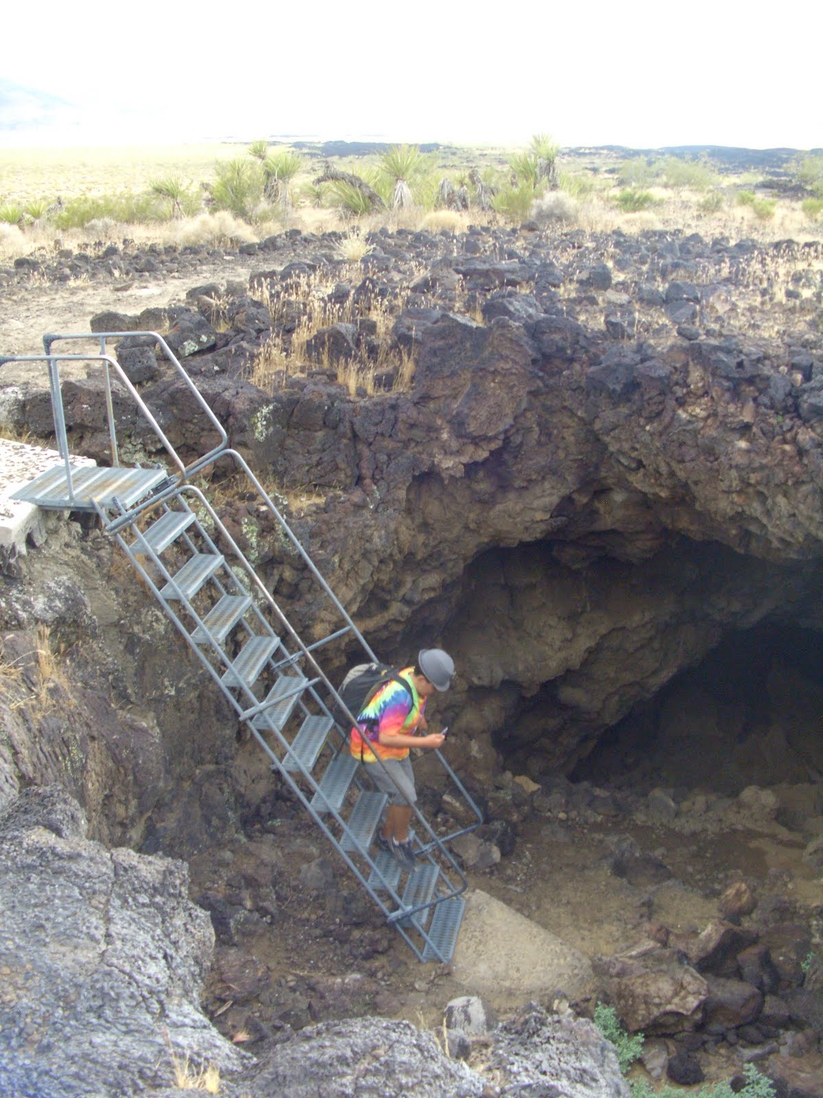
Another 40 feet up the hill we found the tube rntrance and the metal staircase leading down into it. We droped our packs and broke out our headlamps and climbed on in.


After exploring the tube, we returned to the ship and decided that we would ca,p right there in the parking area. I built a cooking fire, while Carlo got the food ready. We enjoyed chili dogs and hot apple cider with the Mojave sunset.


Afton Canyon and The Desert Megaphone

The boys and I have seen all type of nonsence on the high desert. Petroglyphs, pictographs, abandoned mines and homes, deep space telescopes, deeply spacey microphones, 20th century art, rocket ship wreckage....the high desert keeps many secrets. Well, it should come as no suprise to those who know us but we found something new this time out....The Desert Megaphone.

Nobody knows where it came from or who put there, but its out there, in the middle of nowhere. To get to it, we had to re-enter the Preserve through Afton Canyon. We followed what remains of the Mojave River as it runs through Afton Canyon to The Devils Playground in the western part of the Preserve. About 20 miles east of the Afton Canyon Campground sits the Megaphone and some more Mojave petros. It was a heck of a drive to get out there; four-wheel drive and high clearence is a must.

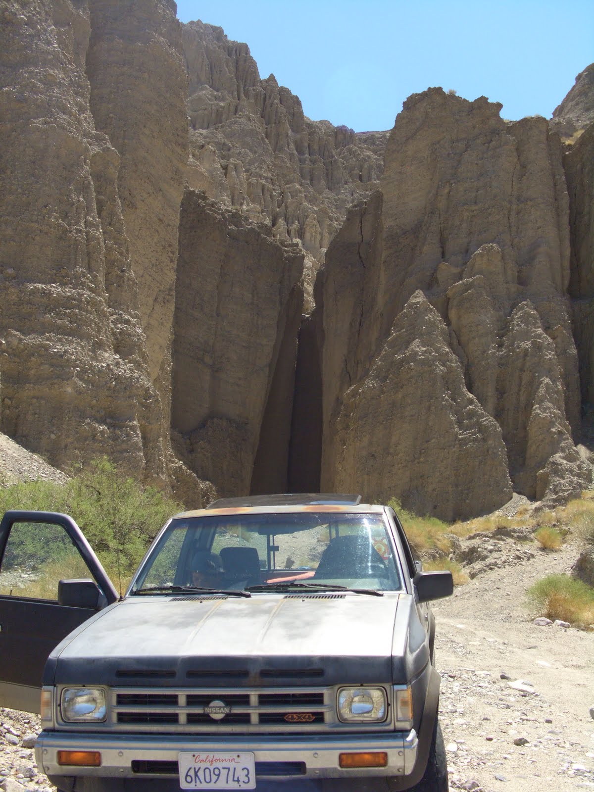
On the way back to the 18, we stoped in Afton Canyon proper to explore some of the very cool badland formations we saw along the way. The Endurance performed like a champ, even in the sandy Mojave River bottom.


There are Union Pacific railroad tracks that run through the canyon and are a continuation of the same rails we crossed at Kelso Depot. As the road we were driving on runs right next to the tracks, we pulled off for a few minutes as a very long train came down the line, kind of thrilling.


With full day of driving still ahead of us we stoped for one last picture as we left Afton Canyon.

The End.